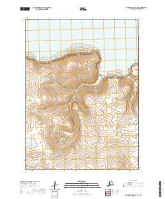
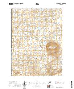
2020 Map of Nunivak Island A-6 NE
USGS Topo · Published 2020About this map
Nash Harbor defines the northern coastline of this maritime landscape on Nunivak Island, where the terrain rises sharply from the Bering Sea into a series of prominent coastal features. High points like Kimixthoruk Hill stand above the interior's complex hydrology, characterized by the wide Lukthlukrit Marsh and isolated basins such as Unroojitok Lake. The coastline is marked by significant navigational landmarks and rocky heights, including Binakslit Bluff, Cape Algonquin, and the southern reaching Ahzwiryuk Bluff. Further east, the topography transitions toward Ahkolikotak Head and the drainage of Dadimawit Kr. The mapping reveals a remote wilderness where landforms and seasonal water bodies dictate the movement of the island's few residents and visiting mariners.
Find a feature on this map
17 named features on this map. Tap any name to fly to it.
Don’t see what you’re looking for? This feature index may not catch every label — zoom into the map to look around manually.
Map Details
Editions of this 2020 Nunivak Island A-6 NE Map
This is the sole edition of this map. No revisions or reprints were ever made.
Other maps of this area

1951 · Nunivak Island
USGS Topo · 1:250,000

1952 · Nunivak Island A-6
USGS Topo · 1:63,360

1952 · Nunivak Island A-5
USGS Topo · 1:63,360
1952 · Nunivak Island B-5
USGS Topo · 1:63,360

1954 · Nunivak Island
USGS Topo · 1:250,000

1958 · Nunivak Island
USGS Topo · 1:250,000

1964 · Nunivak Island
USGS Topo · 1:250,000
2020 · Nunivak Island A-6 SE
USGS Topo · 1:25,000
2020 · Nunivak Island B-5 SW
USGS Topo · 1:25,000
2020 · Nunivak Island A-5 SW
USGS Topo · 1:25,000