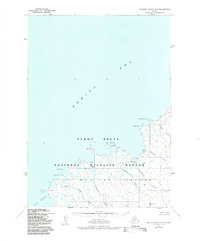
1952 Map of Nunivak Island B-5
USGS Topo · Published 1984About this map
Nunivak Island is documented here during the early 1950s, showing the seasonal settlement patterns of the coastal Yukon Delta National Wildlife Refuge. The map identifies several traditional summer camps, including Abaramiut, Nariksmiut, and Ahdingmiut, positioned where fresh water meets the Bering Sea. These sites reflect the subsistence lifestyle of the era, situated near the mouths of the Ahling River and the Narikmiut River. The coastline is marked by distinct geological features such as Kikitalik Rock and Chingeeruk Pt at the entrance to Nash Harbor. This survey provides a precise look at the island's drainage systems and coastal topography before later administrative changes, preserving the locations of Kahnirukmiut and other culturally significant points along the Kahniruk River.
Find a feature on this map
20 named features on this map. Tap any name to fly to it.
Don’t see what you’re looking for? This feature index may not catch every label — zoom into the map to look around manually.
Map Details
Editions of this 1952 Nunivak Island B-5 Map
2 editions found
Other maps of this area

1951 · Nunivak Island
USGS Topo · 1:250,000

1952 · Nunivak Island A-4
USGS Topo · 1:63,360

1952 · Nunivak Island A-6
USGS Topo · 1:63,360

1952 · Nunivak Island A-5
USGS Topo · 1:63,360
1952 · Nunivak Island B-5
USGS Topo · 1:63,360
1952 · Nunivak Island B-4
USGS Topo · 1:63,360

1954 · Nunivak Island
USGS Topo · 1:250,000

1958 · Nunivak Island
USGS Topo · 1:250,000

1964 · Nunivak Island
USGS Topo · 1:250,000
2020 · Nunivak Island A-6 NE
USGS Topo · 1:25,000