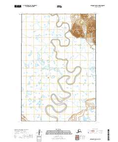
2019 Map of Nushagak Bay D-4 NE
USGS Topo · Published 2019About this map
Manokotak sits at the edge of a massive marshland landscape, its higher ground rising sharply above the winding Igushik River. This modern survey illustrates the proximity of the village to the complex hydrology of Southwest Alaska, where the river meanders in tight oxbows through thousands of small ponds and wetlands. Infrastructure is concentrated around the village core, including the Manokotak Heights Road and the 2nd Street / Airport Access Road, which connects the community to essential transport links. The landscape is defined by the sharp transition between the low-lying river basin and the sudden elevation of the hills immediately surrounding the townsite. This topography dictates the layout of the settlement, keeping development on the firm terrain of the northeastern corner while the rest of the quadrangle remains an untouched network of water and tundra.
Find a feature on this map
10 named features on this map. Tap any name to fly to it.
Don’t see what you’re looking for? This feature index may not catch every label — zoom into the map to look around manually.
Map Details
Editions of this 2019 Nushagak Bay D-4 NE Map
This is the sole edition of this map. No revisions or reprints were ever made.
Other maps of this area

1945 · Nushagak Bay
USGS Topo · 1:250,000

1948 · Nushagak Bay D-4
USGS Topo · 1:63,360

1948 · Nushagak Bay D-3
USGS Topo · 1:63,360

1949 · Nushagak Bay
USGS Topo · 1:250,000

1951 · Dillingham
USGS Topo · 1:250,000

1951 · Goodnews
USGS Topo · 1:250,000

1951 · Nushagak Bay
USGS Topo · 1:250,000

1952 · Nushagak Bay D-3
USGS Topo · 1:63,360

1952 · Nushagak Bay D-4
USGS Topo · 1:63,360

1952 · Dillingham A-8
USGS Topo · 1:63,360