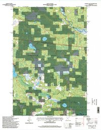
1996 Map of Nushka Lake
USGS Topo · Published 1998About this map
The Mississippi River winds through the northeastern corner of this northern Minnesota landscape, marking the border between Itasca Co and Cass Co. Most of the area is defined by the overlapping boundaries of the Chippewa National Forest and the Leech Lake Indian Reservation, creating a region focused on conservation and tribal land management. This 1996 update reveals a water-dominated terrain with numerous lakes and human-engineered water controls such as the Six Mile Impoundment and Bear Brook Impoundment. Significant industrial infrastructure is present in the form of parallel oil and gas pipelines that cut directly across the northern half of the quadrangle. The southern portion is anchored by the Mud Goose Lake Wildlife Management Area, showcasing the region's dedication to wetland preservation and wildlife habitat within the Bowstring State Forest.
Find a feature on this map
18 named features on this map. Tap any name to fly to it.
Don’t see what you’re looking for? This feature index may not catch every label — zoom into the map to look around manually.
Map Details
Editions of this 1996 Nushka Lake Map
This is the sole edition of this map. No revisions or reprints were ever made.
Other maps of this area

1954 · Bemidji
USGS Topo · 1:250,000

1954 · Hibbing
USGS Topo · 1:250,000

1957 · Bemidji
USGS Topo · 1:250,000

1957 · Hibbing
USGS Topo · 1:250,000

1958 · Bemidji
USGS Topo · 1:250,000

1958 · Hibbing
USGS Topo · 1:250,000

1964 · Hibbing
USGS Topo · 1:250,000

1970 · Ball Club
USGS Topo · 1:24,000
1970 · Little Ball Club Lake
USGS Topo · 1:24,000

1971 · Nushka Lake
USGS Topo · 1:24,000