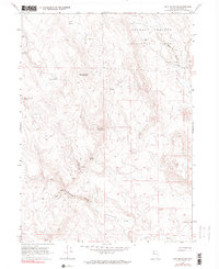
1966 Map of Nut Mountain
USGS Topo · Published 1990About this map
Charles Sheldon Antelope Range dominates this landscape in northern Washoe County, capturing a remote pocket of Nevada as it appeared in the mid-1960s. The terrain is defined by high peaks and sharp descents, with Nut Mountain serving as a central topographical anchor. Water sources are the primary indicators of human and wildlife activity in this arid environment, marked by numerous named points such as Miller and Lux Spring, Little Nut Spring, and Sagehen Spring.
Find a feature on this map
16 named features on this map. Tap any name to fly to it.
Don’t see what you’re looking for? This feature index may not catch every label — zoom into the map to look around manually.
Map Details
Editions of this 1966 Nut Mountain Map
3 editions found
Other maps of this area

1889 · Long Valley
USGS Topo · 1:250,000

1954 · Vya
USGS Topo · 1:250,000

1958 · Vya
USGS Topo · 1:250,000

1962 · Vya
USGS Topo · 1:250,000

1966 · Badger Mtn NW
USGS Topo · 1:24,000

1966 · Massacre Lake
USGS Topo · 1:24,000

1966 · Blowout Mtn
USGS Topo · 1:24,000

1966 · Nut Mountain
USGS Topo · 1:24,000

1966 · Badger Mtn SE
USGS Topo · 1:24,000

1966 · Massacre Creek
USGS Topo · 1:24,000