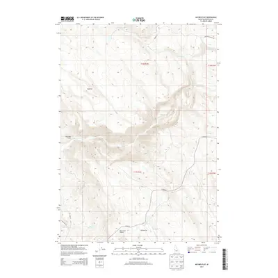
2013 Map of Nutmeg Flat
USGS Topo · Published 2013About this map
Nutmeg Flat and the surrounding high-desert drainage basins of Crane Cr define this territory in Washington County, Idaho. The landscape is marked by sharp elevation changes, notably at Bear Creek Summit and the prominent rise of Sugarloaf. A sparse network of ranching and access roads, including Lower Soulen Ranch Rd and S Crane Rd, reveals the remote character of this region, where the terrain often dictates travel. Water sources are critical but intermittent features of the geography, with Star Butte Cr and the forebodingly named Dead Man Gulch carving paths through the high plateaus. The presence of an Unfinished Rd suggests recent or stalled attempts to further penetrate this complex topography of ridges and creek beds.
Find a feature on this map
18 named features on this map. Tap any name to fly to it.
Don’t see what you’re looking for? This feature index may not catch every label — zoom into the map to look around manually.
Map Details
Editions of this 2013 Nutmeg Flat Map
This is the sole edition of this map. No revisions or reprints were ever made.
Other maps of this area

1897 · Weiser
USGS Topo · 1:125,000

1952 · Weiser Cove
USGS Topo · 1:24,000

1953 · Mann Creek
USGS Topo · 1:62,500

1955 · Baker
USGS Topo · 1:250,000

1957 · Crane Creek Reservoir
USGS Topo · 1:62,500

1959 · Baker
USGS Topo · 1:250,000
1970 · Paddock Valley Reservoir
USGS Topo · 1:24,000
1970 · Holland Gulch
USGS Topo · 1:24,000

1980 · Weiser
USGS Topo · 1:100,000
1986 · Crane Creek Reservoir
USGS Topo · 1:24,000