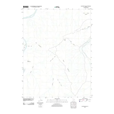
2011 Map of Nutters Hole
USGS Topo · Published 2011About this map
The Green River carves through a high desert landscape in Uintah County, defining the western edge of this 2011 survey. A single Ranch settlement sits near the river's bend, isolated among a complex system of drainage draws and eroded landforms. The terrain transitions from the elevated expanse of the Wild Horse Bench in the northeast to the intricately carved ridges of The Wrinkles and the sweeping curves of the Sumner Amphitheater.
Find a feature on this map
15 named features on this map. Tap any name to fly to it.
Don’t see what you’re looking for? This feature index may not catch every label — zoom into the map to look around manually.
Map Details
Editions of this 2011 Nutters Hole Map
This is the sole edition of this map. No revisions or reprints were ever made.
Other maps of this area

1885 · East Tavaputs
USGS Topo · 1:250,000

1953 · Nutters Hole
USGS Topo · 1:62,500

1953 · Firewater Canyon
USGS Topo · 1:62,500

1956 · Grand Junction
USGS Topo · 1:250,000

1959 · Grand Junction
USGS Topo · 1:250,000

1960 · Grand Junction
USGS Topo · 1:250,000

1962 · Grand Junction
USGS Topo · 1:250,000

1964 · Grand Junction
USGS Topo · 1:250,000

1965 · Grand Junction
USGS Topo · 1:250,000
1966 · Agency Draw NW
USGS Topo · 1:24,000