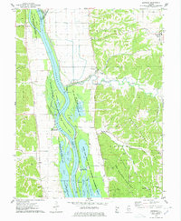
1975 Map of Nutwood
USGS Topo · Published 1978About this map
The Illinois River dominates this mid-1970s landscape, serving as the border between Calhoun and Jersey counties. The eastern bank is defined by the steep bluffs of Rosedale Ridge and Dividing Ridge, where Pere Marquette State Park hosts recreational grounds like Camp Piasa and Camp Quatoga. In the low-lying bottomlands, a complex network of backwaters including Stump Lake, Fuller Lake, and Swan Lake forms part of the Mark Twain National Wildlife Refuge, illustrating the area's significance for migratory waterfowl.
Find a feature on this map
54 named features on this map. Tap any name to fly to it.
Don’t see what you’re looking for? This feature index may not catch every label — zoom into the map to look around manually.
Map Details
Editions of this 1975 Nutwood Map
This is the sole edition of this map. No revisions or reprints were ever made.
Other maps of this area

1903 · O'Fallon
USGS Topo · 1:125,000

1927 · St. Charles
USGS Topo · 1:62,500

1930 · Hardin
USGS Topo · 1:62,500

1930 · Jerseyville
USGS Topo · 1:62,500

1931 · Brussels
USGS Topo · 1:62,500

1933 · Jerseyville
USGS Topo · 1:62,500

1933 · Saint Charles
USGS Topo · 1:62,500

1934 · Hardin
USGS Topo · 1:62,500

1938 · Hardin
USGS Topo · 1:62,500

1939 · Brussels
USGS Topo · 1:62,500