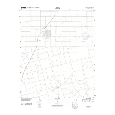
2010 Map of O'Donnell
USGS Topo · Published 2010About this map
O'Donnell anchors this South Plains landscape, where a precise grid of rural routes like Sam Rd and Co Rd V reflects the agricultural character of Lynn and Dawson counties. The town site itself is flanked by the ODonnell Cemetery to the southwest, while the surrounding territory is defined by large-scale land management and ranching, evidenced by the Caprock Ranch. Water management is visible in the southern portion of the sheet at Gravel Pit Lake, which is contained by the Gravel Pit Lake Dam. Transportation corridors such as State Spur 76 and Ranch Rd 2370 weave between section lines, illustrating how modern Texas ranch roads often follow the original survey patterns of the Llano Estacado.
Find a feature on this map
23 named features on this map. Tap any name to fly to it.
Don’t see what you’re looking for? This feature index may not catch every label — zoom into the map to look around manually.
Map Details
Editions of this 2010 O'Donnell Map
This is the sole edition of this map. No revisions or reprints were ever made.
Other maps of this area

1954 · Lubbock
USGS Topo · 1:250,000

1954 · Big Spring
USGS Topo · 1:250,000

1958 · Big Spring
USGS Topo · 1:250,000

1968 · Lamesa North
USGS Topo · 1:24,000

1968 · Hancock
USGS Topo · 1:24,000

1969 · Skeen Lake
USGS Topo · 1:24,000

1969 · Gooch Lake
USGS Topo · 1:24,000

1969 · O'Donnell
USGS Topo · 1:24,000
1969 · Tahoka SW
USGS Topo · 1:24,000

1969 · Indian Canyon
USGS Topo · 1:24,000