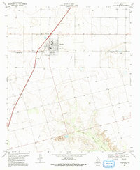
1969 Map of O'Donnell
USGS Topo · Published 1991About this map
The town of O'Donnell anchors this 1969 topographic study, situated precisely at the border of the Lynn Co Dawson Co line in the Texas High Plains. The map captures the agricultural and industrial character of the era, from the grid-patterned streets and Park of the town center to the outlying Rodeo Ground and local Radio Tower. The landscape transitions from the flat tableland of the Staked Plains into the more complex topography of the T J F Draw, where the descent toward the Caprock is evident. Local land use is documented through numerous Gravel Pit locations and several Oil Well sites, reflecting the region's reliance on mineral extraction alongside ranching operations like the Caprock Ranch. A lone Spring in the southern reaches of the quadrangle provides a specific point of interest for researchers of local hydrology and early settlement patterns near the O'Donnell Cem.
Find a feature on this map
12 named features on this map. Tap any name to fly to it.
Don’t see what you’re looking for? This feature index may not catch every label — zoom into the map to look around manually.
Map Details
Editions of this 1969 O'Donnell Map
2 editions found
Other maps of this area

1954 · Lubbock
USGS Topo · 1:250,000

1954 · Big Spring
USGS Topo · 1:250,000

1958 · Big Spring
USGS Topo · 1:250,000

1968 · Lamesa North
USGS Topo · 1:24,000

1968 · Hancock
USGS Topo · 1:24,000

1969 · Skeen Lake
USGS Topo · 1:24,000

1969 · Gooch Lake
USGS Topo · 1:24,000

1969 · O'Donnell
USGS Topo · 1:24,000
1969 · Tahoka SW
USGS Topo · 1:24,000

1969 · Indian Canyon
USGS Topo · 1:24,000