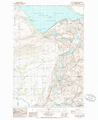
1986 Map of O'Sullivan Dam
USGS Topo · Published 1986About this map
Potholes Reservoir dominates the northern landscape of this mid-1980s survey, representing a significant hydraulic alteration to the central Washington basin. The terrain transitions from the high elevations of the Frenchman Hills down the Royal Slope, where irrigation and drainage patterns are meticulously recorded. Below the dam, the Columbia National Wildlife Refuge preserves a complex network of aquatic environments including Upper Goose Lake and Lower Goose Lake. This area, managed through various designations like the Seep Lakes Habitat Management Area, showcases the managed water systems where Crab Creek and its tributaries like Levee Creek flow through the basin. Numerous smaller water bodies such as Blythe Lake and Chukkar Lake are scattered throughout the refuge, highlighting the intersection of industrial water management and wildlife conservation.
Find a feature on this map
24 named features on this map. Tap any name to fly to it.
Don’t see what you’re looking for? This feature index may not catch every label — zoom into the map to look around manually.
Map Details
Editions of this 1986 O'Sullivan Dam Map
This is the sole edition of this map. No revisions or reprints were ever made.
Other maps of this area

1912 · Moses Lake
USGS Topo · 1:62,500

1923 · Corfu
USGS Topo · 1:62,500

1923 · Wheeler
USGS Topo · 1:62,500

1924 · Othello
USGS Topo · 1:62,500

1925 · Wheeler
USGS Topo · 1:62,500

1951 · Corfu
USGS Topo · 1:62,500

1953 · Walla Walla
USGS Topo · 1:250,000

1953 · Ritzville
USGS Topo · 1:250,000

1954 · Soda Lake
USGS Topo · 1:24,000

1954 · Othello
USGS Topo · 1:24,000