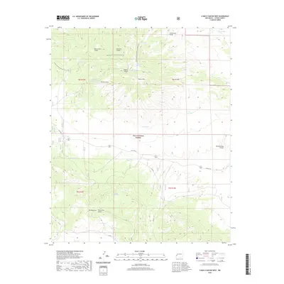
2020 Map of O Bar O Canyon West
USGS Topo · Published 2020About this map
The Continental Divide winds through this high-elevation landscape within the Gila National Forest, defining the watershed of the Elk Mountains. This 2020 map documents a terrain defined by deep drainages and specialized ranching infrastructure, where water management is critical to land use. The presence of numerous livestock watering points, such as O Bar O Mountain Tank, Mesa Redonda Tank, and the J J Pit Tank, highlights the area's continued role in grazing and forestry. The Continental Divide National Scenic Trail traverses the northern section, passing near Mesa Redonda Spring and the prominent O Bar O Mtn. This network of tanks and trails suggests a landscape managed for both utility and recreation, accessible via the winding State Hwy 78 and S Elk Rd that cut through the canyon country.
Find a feature on this map
32 named features on this map. Tap any name to fly to it.
Don’t see what you’re looking for? This feature index may not catch every label — zoom into the map to look around manually.
Map Details
Editions of this 2020 O Bar O Canyon West Map
This is the sole edition of this map. No revisions or reprints were ever made.
Other maps of this area

1911 · Alum Mountain
USGS Topo · 1:125,000

1913 · Alum Mountain
USGS Topo · 1:125,000

1918 · Pelona
USGS Topo · 1:125,000

1954 · Clifton
USGS Topo · 1:250,000

1957 · Clifton
USGS Topo · 1:250,000

1958 · Clifton
USGS Topo · 1:250,000

1962 · Clifton
USGS Topo · 1:250,000
1963 · Loco Mountain
USGS Topo · 1:24,000
1963 · Pitchfork Canyon
USGS Topo · 1:24,000
1965 · Canyon Creek Mountains
USGS Topo · 1:24,000