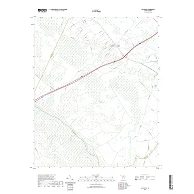
2020 Map of Oak Grove
USGS Topo · Published 2020About this map
Oak Grove sits at a geographic crossroads in the South Carolina coastal plain, where the landscape is defined by the winding course of the Great Pee Dee River and the confluence of numerous wetlands. The map shows a complex hydraulic environment characterized by broad reaches like Poccosin Swamp, Gum Swamp, and Catfish Bay, which dominate the low-lying terrain. While modern infrastructure like Interstate 95 and Rogers Lake Dr bisects the area, the cultural footprint remains anchored by long-standing community landmarks. The presence of the Bethesda Southern Methodist Church and its accompanying Bethesda Southern Methodist Church Cem serves as a focal point for local history. Farther south, the Haselden Cem and Saint George Cem provide critical points of reference for genealogists tracing families in the river-bottom lands between Black Creek and Mill Cr.
Find a feature on this map
53 named features on this map. Tap any name to fly to it.
Don’t see what you’re looking for? This feature index may not catch every label — zoom into the map to look around manually.
Map Details
Editions of this 2020 Oak Grove Map
This is the sole edition of this map. No revisions or reprints were ever made.
Other maps of this area

1940 · Florence East
USGS Topo · 1:62,500

1943 · Gum Swamp
USGS Topo · 1:62,500

1945 · Florence East
USGS Topo · 1:62,500

1947 · Marion
USGS Topo · 1:24,000

1953 · Florence
USGS Topo · 1:250,000

1954 · Florence
USGS Topo · 1:250,000

1960 · Latta
USGS Topo · 1:24,000

1960 · Dillon West
USGS Topo · 1:24,000

1972 · Drake
USGS Topo · 1:24,000
1972 · Oak Grove
USGS Topo · 1:24,000