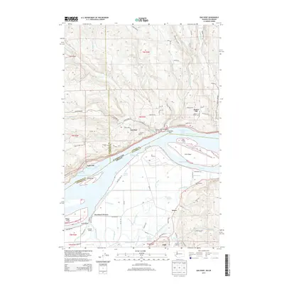
2014 Map of Oak Point
USGS Topo · Published 2014About this map
Oak Point sits at a historic navigation point on the Columbia River, where the river's width is punctuated by Crims Island and the Gull Island Turn. This map documents a complex aquatic landscape of sloughs and channels, including Bradbury Slough and John Slough, which define the low-lying Marshland Division on the Oregon side. The presence of Port Westward and its associated Port Westward Spur highlights the industrial maritime activity required to navigate these shifting waters. Inland, the terrain rises sharply toward Bunker Hill, where a network of logging and local roads like Bunker Hill Rd and Spruce Creek Rd weave through the drainages of Abernathy Creek and Germany Creek. For local historians, several family-named burial sites are mapped, such as Grasseth Cem and Stewart Hill Cem, alongside small riverfront settlements like Eagle Cliff.
Find a feature on this map
99 named features on this map. Tap any name to fly to it.
Don’t see what you’re looking for? This feature index may not catch every label — zoom into the map to look around manually.
Map Details
Editions of this 2014 Oak Point Map
This is the sole edition of this map. No revisions or reprints were ever made.
Other maps of this area

1919 · Mayger
USGS Topo · 1:62,500

1941 · Skamokawa
USGS Topo · 1:62,500

1941 · Clatskanie
USGS Topo · 1:62,500

1941 · Cathlamet
USGS Topo · 1:62,500

1952 · Clatskanie
USGS Topo · 1:62,500

1953 · Hoquiam
USGS Topo · 1:250,000

1953 · Ryderwood
USGS Topo · 1:62,500

1953 · Skamokawa
USGS Topo · 1:62,500

1953 · Cathlamet
USGS Topo · 1:62,500

1957 · Hoquiam
USGS Topo · 1:250,000