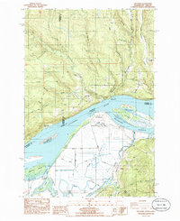
1985 Map of Oak Point
USGS Topo · Published 1985About this map
The Columbia River serves as the central artery for this mid-1980s landscape, marking the boundary between Washington and Oregon. On the northern bank, the settlements of Oak Point and Bunker Hill sit among a network of drainages including Abernathy Creek and Germany Creek. This area is punctuated by small family and community landmarks such as the Oak Point Cem, Bunker Hill Cem, and the Bunker Hill Grange. The terrain shifts across the water to the Oregon side, where the industrialized Port Westward and the Beaver Generating Plant stand near the maze of channels including Bradbury Slough and Pojsky Slough. This survey captures a transitional moment for local infrastructure, noting an Abandoned RR Trestle crossing the water near the state line, while large land masses like Crims Island and Gull Island fragment the river's flow.
Find a feature on this map
49 named features on this map. Tap any name to fly to it.
Don’t see what you’re looking for? This feature index may not catch every label — zoom into the map to look around manually.
Map Details
Editions of this 1985 Oak Point Map
This is the sole edition of this map. No revisions or reprints were ever made.
Other maps of this area

1919 · Mayger
USGS Topo · 1:62,500

1941 · Skamokawa
USGS Topo · 1:62,500

1941 · Clatskanie
USGS Topo · 1:62,500

1941 · Cathlamet
USGS Topo · 1:62,500

1952 · Clatskanie
USGS Topo · 1:62,500

1953 · Hoquiam
USGS Topo · 1:250,000

1953 · Ryderwood
USGS Topo · 1:62,500

1953 · Skamokawa
USGS Topo · 1:62,500

1953 · Cathlamet
USGS Topo · 1:62,500

1957 · Hoquiam
USGS Topo · 1:250,000