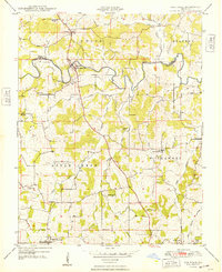
1948 Map of Oak Ridge
USGS Topo · Published 1948About this map
Apple Creek meanders across the border of Perry and Cape Girardeau counties, serving as the central geographic feature for several small agricultural communities in the late 1940s. The settlement of Appleton and the adjacent Old Appleton (PO) occupy a strategic crossing point where the topography transitions into the hills of the Apple Creek and Shawnee townships. The landscape is dotted with numerous small country schools, such as Buckeye Sch and Apple Creek Valley School, reflecting a decentralized rural education system prior to widespread district consolidation.
Find a feature on this map
32 named features on this map. Tap any name to fly to it.
Don’t see what you’re looking for? This feature index may not catch every label — zoom into the map to look around manually.
Map Details
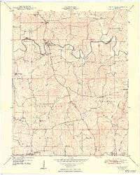
Editions of this 1948 Oak Ridge Map
2 editions found
Other maps of this area

1918 · Altenburg
USGS Topo · 1:62,500

1922 · Cape Girardeau
USGS Topo · 1:62,500

1923 · Perryville
USGS Topo · 1:62,500

1924 · Cape Girardeau
USGS Topo · 1:62,500

1924 · Perryville
USGS Topo · 1:62,500

1925 · Altenburg
USGS Topo · 1:62,500

1933 · Marble Hill
USGS Topo · 1:62,500

1937 · Marble Hill
USGS Topo · 1:62,500

1947 · Crosstown
USGS Topo · 1:24,000

1947 · Oak Ridge
USGS Topo · 1:24,000