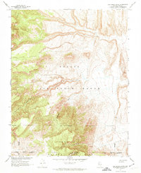
1962 Map of Oak Spring Butte
USGS Topo · Published 1974About this map
Nevada Test Site and Nellis Air Force Range dominate this landscape, reflecting a specialized mid-century era of military and atomic research in Nye County. Surveyed in 1962 in cooperation with the Atomic Energy Commission, the map details the restricted administrative lines of Area 15 Boundary and Area 12 Bdy. These governmental borders cut through a dramatic topography defined by the Belted Range and the prominent Big Dome.
Find a feature on this map
11 named features on this map. Tap any name to fly to it.
Don’t see what you’re looking for? This feature index may not catch every label — zoom into the map to look around manually.
Map Details
Editions of this 1962 Oak Spring Butte Map
2 editions found
Other maps of this area

1908 · Kawich
USGS Topo · 1:250,000

1942 · Emigrant Valley
USGS Topo · 1:125,000

1942 · Wheelbarrow Peak
USGS Topo · 1:125,000

1952 · Tippipah Spring
USGS Topo · 1:62,500

1952 · Papoose Lake
USGS Topo · 1:62,500

1952 · Wheelbarrow Peak
USGS Topo · 1:62,500

1952 · Groom Mine
USGS Topo · 1:62,500

1954 · Caliente
USGS Topo · 1:250,000

1954 · Goldfield
USGS Topo · 1:250,000

1955 · Goldfield
USGS Topo · 1:250,000