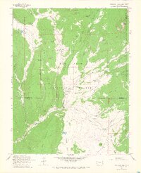
1964 Map of Oakbrush Ridge
USGS Topo · Published 1967About this map
The San Juan National Forest defines this high-altitude landscape where the Piedra River meets its tributaries in Archuleta and Hinsdale counties. During the mid-1960s, this area served as a focal point for both government management and early recreational development, anchored by the Piedra Guard Station and the Williams Creek Campground. Cultural life in this isolated ranching and timber environment centered on locations like Debs Community Hall, while family-named holdings such as Singing Pines Ranch and Klockner Ranch dot the eastern draws. The intricate network of pack trails and stock paths, including the Burro Park Jeep Trail, reflects a landscape managed for movement through steep terrain. Notable landmarks like Deadman Curve and Salty Overlook provide specific geographic context to the winding roads that follow the river valleys, while The Cow Camp highlights the enduring importance of seasonal livestock grazing in the national forest during this era.
Find a feature on this map
52 named features on this map. Tap any name to fly to it.
Don’t see what you’re looking for? This feature index may not catch every label — zoom into the map to look around manually.
Map Details
Editions of this 1964 Oakbrush Ridge Map
4 editions found

Other maps of this area

1905 · San Cristobal
USGS Topo · 1:125,000

1907 · San Cristobal
USGS Topo · 1:125,000

1924 · Pagosa Springs
USGS Topo · 1:125,000

1927 · Pagosa Springs
USGS Topo · 1:125,000

1945 · Durango
USGS Topo · 1:250,000

1953 · Durango
USGS Topo · 1:250,000

1954 · Durango
USGS Topo · 1:250,000

1961 · Durango
USGS Topo · 1:250,000

1963 · Durango
USGS Topo · 1:250,000
1964 · Chris Mountain
USGS Topo · 1:24,000