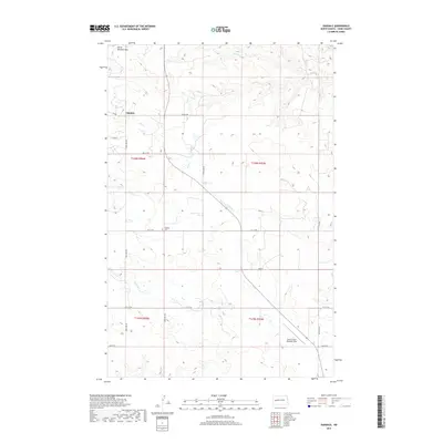
2017 Map of Oakdale
USGS Topo · Published 2017About this map
North Killdeer Mtn dominates the northwestern horizon of this North Dakota landscape, overseeing a region defined by its rugged drainage networks and rural crossroads. The small settlement of Oakdale serves as a local anchor, situated near the headwaters of Jim Creek and north of Oakdale Cem. The map reveals a highly structured grid of section lines and gravel roads, including Gap Rd and 109th Ave NW, which partition the cattle country of Dunn County. To the southeast, the Dunn County Weydahl Field provides a modern aviation landmark amidst the winding paths of Gumbo Creek and Frank Creek. This survey captures the persistent rural character of the northern plains, where land use is dictated by the deeply etched creek beds and the high promontories of the Killdeer Mountains.
Find a feature on this map
23 named features on this map. Tap any name to fly to it.
Don’t see what you’re looking for? This feature index may not catch every label — zoom into the map to look around manually.
Map Details
Editions of this 2017 Oakdale Map
This is the sole edition of this map. No revisions or reprints were ever made.
Other maps of this area

1953 · Watford City
USGS Topo · 1:250,000

1957 · Watford City
USGS Topo · 1:250,000
1958 · North Killdeer Mountain
USGS Topo · 1:24,000

1967 · Watford City
USGS Topo · 1:250,000
1970 · Lost Bridge
USGS Topo · 1:24,000
1970 · Dunn Center NW
USGS Topo · 1:24,000
1970 · Mandaree SW
USGS Topo · 1:24,000
1973 · Lake Ilo
USGS Topo · 1:24,000
1974 · Killdeer
USGS Topo · 1:100,000
1974 · Fayette
USGS Topo · 1:24,000