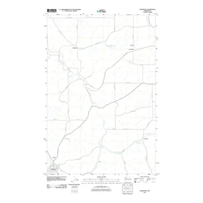
2011 Map of Oakesdale
USGS Topo · Published 2011About this map
Oakesdale serves as the primary hub in this eastern Washington landscape, situated where McCoy Creek meets the headwaters of Pine Creek. The surrounding Palouse terrain is defined by a network of small agricultural settlements including Fairbanks, Seabury, and Lone Pine, each connected by a grid of rural roads and the John Wayne Trl. This corridor traces the historic path of transit and commerce that once linked these high-prairie outposts. Genealogists can locate family landmarks such as the Lone Pine Cemetery and Oakesdale Cemetery, while several ephemeral settlements like Warner and Fletcher mark the points where rail and road once supported a denser population of growers. Numerous watercourses, including Cabbage Creek and Spring Creek, carve through the rolling hills, illustrating the drainage patterns that have shaped the region's productive wheat country for generations.
Find a feature on this map
47 named features on this map. Tap any name to fly to it.
Don’t see what you’re looking for? This feature index may not catch every label — zoom into the map to look around manually.
Map Details
Editions of this 2011 Oakesdale Map
This is the sole edition of this map. No revisions or reprints were ever made.
Other maps of this area

1903 · Oakesdale
USGS Topo · 1:125,000

1905 · Oakesdale
USGS Topo · 1:125,000

1954 · Spangle
USGS Topo · 1:62,500

1954 · Fairfield
USGS Topo · 1:62,500

1955 · Spokane
USGS Topo · 1:250,000

1958 · Spokane
USGS Topo · 1:250,000

1964 · Oakesdale
USGS Topo · 1:24,000

1964 · Tekoa
USGS Topo · 1:24,000
1964 · Steptoe
USGS Topo · 1:24,000
1964 · Garfield
USGS Topo · 1:24,000