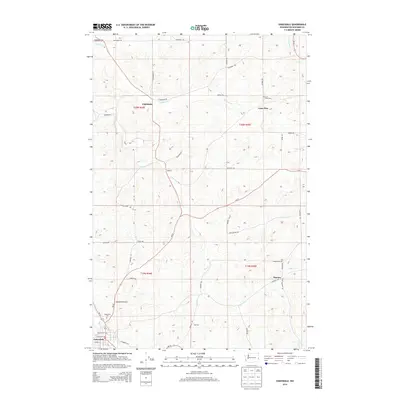
2014 Map of Oakesdale
USGS Topo · Published 2014About this map
Oakesdale stands as the primary hub in this corner of Whitman County, situated where McCoy Cr meets the larger drainage system of the Palouse. The town's grid is detailed with street-level accuracy, including Pearl St and William St, alongside the Oakesdale Cem and the Oakesdale Airport. Stretching north, the landscape is defined by the winding course of Pine Cr and a series of smaller agricultural settlements like Seabury and Fairbanks. These communities are connected by a network of rural routes such as Fairbanks Rd and Wa-27, reflecting a long-standing reliance on the region's productive grain-growing hills. To the east, the map captures the transition into more isolated terrain near Lone Pine and the Lone Pine Cem, where smaller waterways like Cabbage Cr and Willow Cr carve through the undulating topography.
Find a feature on this map
49 named features on this map. Tap any name to fly to it.
Don’t see what you’re looking for? This feature index may not catch every label — zoom into the map to look around manually.
Map Details
Editions of this 2014 Oakesdale Map
This is the sole edition of this map. No revisions or reprints were ever made.
Other maps of this area

1903 · Oakesdale
USGS Topo · 1:125,000

1905 · Oakesdale
USGS Topo · 1:125,000

1954 · Spangle
USGS Topo · 1:62,500

1954 · Fairfield
USGS Topo · 1:62,500

1955 · Spokane
USGS Topo · 1:250,000

1958 · Spokane
USGS Topo · 1:250,000

1964 · Oakesdale
USGS Topo · 1:24,000

1964 · Tekoa
USGS Topo · 1:24,000
1964 · Steptoe
USGS Topo · 1:24,000
1964 · Garfield
USGS Topo · 1:24,000