1905 Map of Oakesdale
USGS Topo · Published 1938About this map
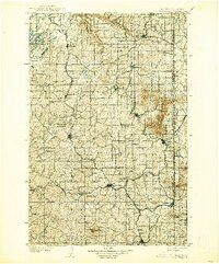
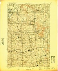
Oakesdale stands as a central rail hub in the early twentieth century, where the agriculture-driven economy of the Palouse is clearly visible through a dense grid of township lines and rail corridors. This survey, conducted by A. E. Murlin and geographer E. M. Douglas, illustrates the vital transport networks of the Northern Pacific RR and the Union Pacific (Waverly Br) connecting remote settlements. The terrain is defined by prominent basalt features rising from the plateau, most notably Steptoe Butte and Tekoa Mountain, which serve as dramatic landmarks against the surrounding wheat country. Smaller communities such as Rosalia, Farmington, and Rockford appear as established townsites during this period of expansion. The map also delineates the Washington Idaho State Boundary Line, showing how political borders intersected the natural drainage of Latah Creek and Rock Creek.
Find a feature on this map
47 named features on this map. Tap any name to fly to it.
Don’t see what you’re looking for? This feature index may not catch every label — zoom into the map to look around manually.
Map Details
Editions of this 1905 Oakesdale Map
3 editions found
Other maps of this area

1901 · Spokane
USGS Topo · 1:125,000

1903 · Oakesdale
USGS Topo · 1:125,000

1903 · Rathdrum
USGS Topo · 1:125,000

1905 · Oakesdale
USGS Topo · 1:125,000

1910 · Pullman
USGS Topo · 1:125,000

1943 · Medical Lake
USGS Topo · 1:62,500

1949 · Greenacres
USGS Topo · 1:62,500
1950 · Spokane SE
USGS Topo · 1:24,000
1950 · Endicott
USGS Topo · 1:62,500

1950 · Spokane SW
USGS Topo · 1:24,000