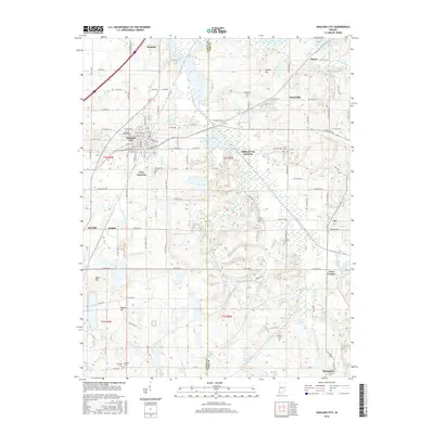
2016 Map of Oakland City
USGS Topo · Published 2016About this map
Oakland City serves as the primary hub in this southwestern Indiana landscape, where the campus of Oakland City Univ and the intersection of the Norfolk Southern rail line anchor the local community. The surrounding terrain is defined by the winding course of the South Fork Patoka River and numerous tributaries such as Hurricane Cr and Honey Cr. Rural life is marked by several small junctions and outlying settlements, including Dongola to the north and Spurgeon to the south. Genealogists will find a high density of family and community burial grounds, such as Montgomery Cem, Williams Cem, and Coleman Cem, scattered across the Gibson and Pike county line. The presence of several large water bodies like New Lake and Old Lake highlights the region's managed water resources and drainage patterns including the Barren Ditch.
Find a feature on this map
85 named features on this map. Tap any name to fly to it.
Don’t see what you’re looking for? This feature index may not catch every label — zoom into the map to look around manually.
Map Details
Editions of this 2016 Oakland City Map
This is the sole edition of this map. No revisions or reprints were ever made.
Other maps of this area

1900 · De Gonia Springs
USGS Topo · 1:62,500

1902 · Ditney
USGS Topo · 1:125,000

1902 · Degonia Springs
USGS Topo · 1:62,500

1902 · Boonville
USGS Topo · 1:62,500

1903 · Velpen
USGS Topo · 1:62,500

1903 · Petersburg
USGS Topo · 1:62,500

1956 · Vincennes
USGS Topo · 1:250,000

1957 · Vincennes
USGS Topo · 1:250,000

1958 · Vincennes
USGS Topo · 1:250,000
1960 · Folsomville
USGS Topo · 1:24,000