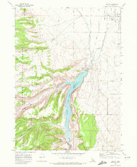
1968 Map of Oakley
USGS Topo · Published 1972About this map
The agricultural settlement of Oakley serves as the focal point for this 1968 survey, showing the town's grid positioned between the Union Pacific railroad and the extensive water management system of southern Idaho. The Lower Goose Creek Reservoir is the landscape's dominant feature, held by the Oakley Dam and supported by an intricate network of canals including the West Canal and East Canal. This system transformed the arid terrain of Cassia County into productive farmland at the edge of the wilderness.
Find a feature on this map
36 named features on this map. Tap any name to fly to it.
Don’t see what you’re looking for? This feature index may not catch every label — zoom into the map to look around manually.
Map Details
Editions of this 1968 Oakley Map
2 editions found
Other maps of this area

1954 · Pocatello
USGS Topo · 1:250,000

1955 · Twin Falls
USGS Topo · 1:250,000

1958 · Twin Falls
USGS Topo · 1:250,000

1958 · Pocatello
USGS Topo · 1:250,000

1965 · Buckhorn Canyon
USGS Topo · 1:24,000

1968 · Basin
USGS Topo · 1:24,000
1968 · Blue Hill
USGS Topo · 1:24,000

1968 · Marion SE
USGS Topo · 1:24,000

1968 · Lyman Pass
USGS Topo · 1:24,000
1968 · Marion
USGS Topo · 1:24,000