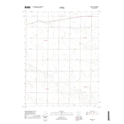
2018 Map of Oakley SW
USGS Topo · Published 2018About this map
N Br Hackberry Cr and its tributaries carve a network of drainage patterns across this Logan County landscape, defining the rural character of the High Plains. The map reveals a systematic grid of section lines and county roads, such as Co RD 380 and Co RD 400, which provide the primary framework for navigation through these vast agricultural tracts. Scattered throughout the townships of t11s r33w and t12s r32w are localized identifiers including Eagle Eye, Day Dream, and Apache Acre, which likely represent specific local property names or land tracts. The transition from the northern reaches near Broken Bow to the southern drainages of S Br Hackberry Cr showcases a topography dominated by erosion-carved draws and intermittent stream beds characteristic of the Kansas prairie.
Find a feature on this map
23 named features on this map. Tap any name to fly to it.
Don’t see what you’re looking for? This feature index may not catch every label — zoom into the map to look around manually.
Map Details
Editions of this 2018 Oakley SW Map
This is the sole edition of this map. No revisions or reprints were ever made.
Other maps of this area

1954 · Goodland
USGS Topo · 1:250,000

1955 · Scott City
USGS Topo · 1:250,000

1956 · Goodland
USGS Topo · 1:250,000

1957 · Goodland
USGS Topo · 1:250,000

1958 · Scott City
USGS Topo · 1:250,000
1972 · Monument
USGS Topo · 1:24,000
1972 · Winona NE
USGS Topo · 1:24,000
1972 · Elkader NW
USGS Topo · 1:24,000
1972 · Elkader NE
USGS Topo · 1:24,000
1972 · Russell Springs NE
USGS Topo · 1:24,000