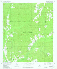
1980 Map of Oakmulgee
USGS Topo · Published 1980About this map
Talladega National Forest covers much of this landscape in western Alabama, centered around the settlement of Oakmulgee and the winding Oakmulgee Creek. The terrain is defined by a dense network of tributaries including Beaverdam Creek, Boiling Mill Creek, and Dutch Creek, which have carved deep drainage patterns throughout the timberland. Genealogists will find a cluster of family and community landmarks, particularly on the western side of the forest where Bethlehem Cemetery, Legal Cemetery, and Barnett Cemetery are located. Several country churches, such as Liberty Ch and Friendship Ch, anchor the small rural pockets along the county lines. The presence of numerous Gravel Pits scattered near the creek beds reflects the local extractive activity that occurred as Ala 5 and other transit routes moved through the woods toward the Bibb and Chilton county borders.
Find a feature on this map
29 named features on this map. Tap any name to fly to it.
Don’t see what you’re looking for? This feature index may not catch every label — zoom into the map to look around manually.
Map Details
Editions of this 1980 Oakmulgee Map
2 editions found
Other maps of this area

1891 · Clanton
USGS Topo · 1:125,000

1953 · Montgomery
USGS Topo · 1:250,000

1956 · Montgomery
USGS Topo · 1:250,000

1957 · Montgomery
USGS Topo · 1:250,000

1959 · Plantersville
USGS Topo · 1:62,500

1959 · Summerfield
USGS Topo · 1:62,500

1971 · Maplesville West
USGS Topo · 1:24,000
1971 · Randolph
USGS Topo · 1:24,000

1979 · Harrisburg
USGS Topo · 1:24,000
1980 · Centreville East
USGS Topo · 1:24,000