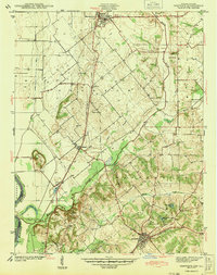
1943 Map of Oaktown
USGS Topo · Published 1943About this map
The Wabash River forms the western boundary of this Knox County landscape, where the fertile bottomlands meet rising terrain to the east. Oaktown and Bruceville serve as primary hubs, connected by a network of rural roads and the Chicago and Eastern Illinois railroad. The map reveals a dense distribution of family-named cemeteries such as Ocheltree Cem, Threlkeld Cem, and Price Cem, providing critical touchpoints for genealogical research. Drainage systems like the Prairie Ditch and Illinois Eastern Ditch highlight the intensive agricultural management of the era. To the south, the landscape shifts toward the South Fork Maria Creek, where the Rod and Gun Club Lake and Cleveland Pond offer a look at local recreation spots amidst the farms and small settlements of Busseron and Emison.
Find a feature on this map
32 named features on this map. Tap any name to fly to it.
Don’t see what you’re looking for? This feature index may not catch every label — zoom into the map to look around manually.
Map Details
Editions of this 1943 Oaktown Map
2 editions found
Other maps of this area

1915 · Vincennes
USGS Topo · 1:62,500

1917 · Birds
USGS Topo · 1:62,500

1942 · Fritchton
USGS Topo · 1:24,000

1942 · Birds
USGS Topo · 1:62,500

1943 · Carlisle
USGS Topo · 1:24,000

1943 · Oaktown
USGS Topo · 1:24,000

1943 · Bicknell
USGS Topo · 1:24,000

1944 · Bucktown
USGS Topo · 1:24,000

1944 · Fritchton
USGS Topo · 1:24,000

1944 · Wheatland
USGS Topo · 1:24,000