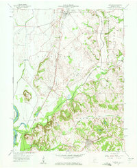
1958 Map of Oaktown
USGS Topo · Published 1959About this map
Oaktown and the surrounding agricultural landscape of Knox County define this 1950s survey of southwestern Indiana. The rail-oriented development of the era is evident along the Chicago and Eastern Illinois railroad, which links the settlements of Busseron and Emison. The terrain transitions from the low-lying Shaker Prairie Ditch system near the Wabash River to the more dissected uplands around Bruceville. Local history is preserved in numerous rural landmarks, including the Maria Creek Ch and family-named burial sites such as Ocheltree Cem and Threlkeld Cem.
Find a feature on this map
37 named features on this map. Tap any name to fly to it.
Don’t see what you’re looking for? This feature index may not catch every label — zoom into the map to look around manually.
Map Details
Editions of this 1958 Oaktown Map
2 editions found
Other maps of this area

1915 · Vincennes
USGS Topo · 1:62,500

1917 · Birds
USGS Topo · 1:62,500

1942 · Fritchton
USGS Topo · 1:24,000

1942 · Birds
USGS Topo · 1:62,500

1943 · Carlisle
USGS Topo · 1:24,000

1943 · Oaktown
USGS Topo · 1:24,000

1943 · Bicknell
USGS Topo · 1:24,000

1944 · Bucktown
USGS Topo · 1:24,000

1944 · Fritchton
USGS Topo · 1:24,000

1944 · Wheatland
USGS Topo · 1:24,000