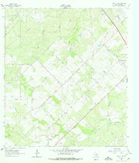
1963 Map of Oakville SW
USGS Topo · Published 1978About this map
Oil and gas exploration dominates this portion of Live Oak County in the early 1960s, evidenced by a dense network of pipelines and wells crisscrossing the landscape. The George West Oil Field and Maxine Oil Field occupy large swaths of the terrain, while the northern edge is defined by the Clayton Field. This industrial activity is centered near the regional transportation hub of George West, with the Missouri Pacific railroad line cutting diagonally across the northeastern corner.
Find a feature on this map
20 named features on this map. Tap any name to fly to it.
Don’t see what you’re looking for? This feature index may not catch every label — zoom into the map to look around manually.
Map Details
Editions of this 1963 Oakville SW Map
2 editions found
Other maps of this area

1920 · Mikeska
USGS Topo · 1:125,000

1925 · Oakville No. 4
USGS Topo · 1:48,000

1925 · Simmons No. 1
USGS Topo · 1:48,000

1927 · Oakville
USGS Topo · 1:62,500

1929 · Simmons
USGS Topo · 1:62,500

1953 · Crystal City
USGS Topo · 1:250,000

1955 · Crystal City
USGS Topo · 1:250,000

1961 · Crystal City
USGS Topo · 1:250,000
1963 · Crater Ridge
USGS Topo · 1:24,000
1963 · Elm Creek
USGS Topo · 1:24,000