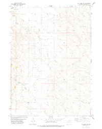
1978 Map of Oat Creek NW
USGS Topo · Published 1979About this map
Antelope Creek defines the drainage of this Niobrara County landscape, winding south across a high-plains terrain marked by energy exploration and ranching infrastructure in the late 1970s. The land is largely open, though human presence is noted through several energy-related landmarks such as an Oil Well and a Drill Hole. In the southern portion of the quadrangle, Boner Landing Strips appears near the banks of Black Tail Creek, indicating a reliance on light aircraft for regional connectivity across this expansive range. Several other seasonal waterways, including Wheatgrass Draw and North Cottonwood Creek, fragment the topography, illustrating the complex watershed patterns that dictate life and land use in this part of Wyoming. This survey captures a moment when the rural character of the state was increasingly intersected by industrial probing and private aviation.
Find a feature on this map
13 named features on this map. Tap any name to fly to it.
Don’t see what you’re looking for? This feature index may not catch every label — zoom into the map to look around manually.
Map Details
Editions of this 1978 Oat Creek NW Map
This is the sole edition of this map. No revisions or reprints were ever made.
Other maps of this area

1955 · Newcastle
USGS Topo · 1:250,000

1958 · Newcastle
USGS Topo · 1:250,000

1978 · Mule Creek
USGS Topo · 1:24,000

1978 · Coffee Flats
USGS Topo · 1:24,000
1978 · South Oat Creek
USGS Topo · 1:24,000
1978 · Oat Creek
USGS Topo · 1:24,000
1978 · Mule Creek SE
USGS Topo · 1:24,000
1981 · Coyote Gap
USGS Topo · 1:24,000
1981 · Redbird
USGS Topo · 1:24,000
1981 · Bowen Flat
USGS Topo · 1:24,000