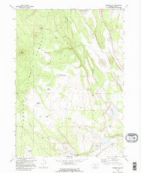
1968 Map of Oatman Flat
USGS Topo · Published 1995About this map
Fremont National Forest dominates the western half of this Oregon landscape, transitioning into the expansive high-desert terrain of Oatman Flat to the east. Remote outposts and seasonal camps are scattered throughout the territory, including the Wing Butte Cabin near its namesake peak and Feeman Dry Camp. These locations, alongside named family homesteads like Stratton Place and Deadmond Place, provide a clear picture of the isolated ranching and forestry infrastructure of the late 1960s. Water is a defining resource in this arid environment, marked by numerous isolated sources such as Baskin Spring, Meadow Waterhole, and Halfway Lake. The map reveals a network of primitive transportation including a Jeep Trail cutting across the central portion, connecting the distinct geological features of Wing Butte and Oat Butte with the surrounding volcanic flats.
Find a feature on this map
24 named features on this map. Tap any name to fly to it.
Don’t see what you’re looking for? This feature index may not catch every label — zoom into the map to look around manually.
Map Details
Editions of this 1968 Oatman Flat Map
2 editions found
Other maps of this area

1955 · Crescent
USGS Topo · 1:250,000

1957 · Crescent
USGS Topo · 1:250,000

1958 · Crescent
USGS Topo · 1:250,000

1968 · Silver Lake
USGS Topo · 1:24,000

1968 · Rodman Rock
USGS Topo · 1:24,000

1968 · Oatman Flat
USGS Topo · 1:24,000
1968 · Hager Mtn
USGS Topo · 1:24,000
1968 · Antelope Mtn
USGS Topo · 1:24,000
1968 · Bridge Creek Draw
USGS Topo · 1:24,000

1970 · Crescent
USGS Topo · 1:250,000