
1951 Map of Oberlin
USGS Topo · Published 1952About this map
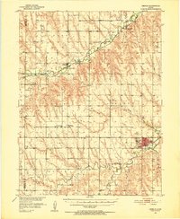
Oberlin serves as the focal point of this 1951 topographic survey of Decatur County, situated at the confluence of Sappa Creek and the railroad lines of the CB&Q. The map reveals a post-war rural landscape organized around the Chicago Burlington and Quincy tracks, which connect small settlements like Traer and Cedar Bluffs. The distribution of School No 11, Mt Pleasant Sch, and Addleman Sch alongside numerous country churches and cemeteries, such as St Johns Ch and Fairview Cem, provides a detailed record of mid-century community life and genealogy.
Find a feature on this map
36 named features on this map. Tap any name to fly to it.
Don’t see what you’re looking for? This feature index may not catch every label — zoom into the map to look around manually.
Map Details
Editions of this 1951 Oberlin Map
2 editions found
Other maps of this area

1951 · Selden
USGS Topo · 1:62,500

1951 · Herndon
USGS Topo · 1:62,500

1951 · Achilles
USGS Topo · 1:62,500

1951 · Kanona
USGS Topo · 1:62,500

1954 · McCook
USGS Topo · 1:250,000

1954 · Goodland
USGS Topo · 1:250,000

1956 · Goodland
USGS Topo · 1:250,000

1957 · McCook
USGS Topo · 1:250,000

1957 · Goodland
USGS Topo · 1:250,000

1957 · McCook SW
USGS Topo · 1:24,000