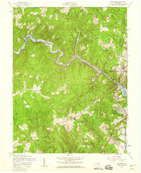
1956 Map of Occoquan
USGS Topo · Published 1959About this map
The Occoquan Creek serves as a winding natural boundary between Fairfax and Prince William counties, defining the character of this mid-century Virginia landscape. Near the riverside settlement of Occoquan, the Occoquan Dam and Elk Horn Pumping Sta mark the intersection of natural waterways and growing infrastructure. Industrial footprints are visible at the Quarries and Clay Pit, while the Richmond Fredericksburg and Potomac railroad corridor facilitates transport near the coast.
Find a feature on this map
46 named features on this map. Tap any name to fly to it.
Don’t see what you’re looking for? This feature index may not catch every label — zoom into the map to look around manually.
Map Details
Editions of this 1956 Occoquan Map
4 editions found
Other maps of this area

1890 · Mt. Vernon
USGS Topo · 1:125,000

1891 · Mt. Vernon
USGS Topo · 1:125,000

1894 · Mt. Vernon
USGS Topo · 1:125,000

1897 · Mt. Vernon
USGS Topo · 1:125,000

1900 · Washington
USGS Topo · 1:62,500

1913 · Indian Head
USGS Topo · 1:62,500

1915 · Fairfax
USGS Topo · 1:62,500

1923 · Indian Head
USGS Topo · 1:48,000

1925 · Indian Head
USGS Topo · 1:62,500

1927 · Quantico
USGS Topo · 1:62,500