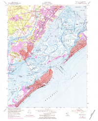
1952 Map of Ocean City
USGS Topo · Published 1984About this map
Ocean City dominates the barrier island landscape of Peck Beach in this mid-century survey, showing the dense grid of vacation homes and local businesses along Asbury Ave and Central Ave. The resort’s connection to the mainland is defined by the Pennsylvania-Reading Seashore Lines, which provided critical rail access for tourists and residents alike during this era of coastal development. Across the Great Egg Harbor Bay, the mainland towns of Somers Point and Linwood serve as established gateways, marked by historic sites like Zion Cem and the Atlantic City Country Club. The map reveals a complex network of tidal waterways and islands, including the Rainbow Islands and Pork Island, illustrating the intricate geography of the New Jersey shore before modern expansion. This document captures the transition of the region from a collection of maritime settlements into a structured suburban and resort corridor.
Find a feature on this map
65 named features on this map. Tap any name to fly to it.
Don’t see what you’re looking for? This feature index may not catch every label — zoom into the map to look around manually.
Map Details
Editions of this 1952 Ocean City Map
4 editions found
Other maps of this area

1884 · Sea Isle
USGS Topo · 1:62,500

1887 · Atlantic City
USGS Topo · 1:62,500

1888 · Sea Isle
USGS Topo · 1:62,500

1890 · Great Egg Harbor
USGS Topo · 1:62,500

1893 · Great Egg Harbor
USGS Topo · 1:62,500

1894 · Sea Isle
USGS Topo · 1:62,500

1894 · Atlantic City
USGS Topo · 1:62,500

1918 · Great Egg Harbor
USGS Topo · 1:62,500

1919 · Sea Isle
USGS Topo · 1:62,500

1940 · Atlantic City
USGS Topo · 1:62,500