
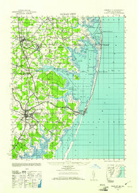
1942 Map of Ocean City
USGS Topo · Published 1942About this map
Ocean City and the surrounding coastal wetlands of Maryland and Delaware appear in high detail just after the start of World War II. The landscape is defined by the narrow barrier strand and the expansive back bays, including Little Assawoman Bay and Assawoman Bay. Transportation networks show a heavy reliance on rail, with the Pennsylvania Railroad running through Berlin and the Baltimore and Virginia Railroad terminating near the coast.
Find a feature on this map
81 named features on this map. Tap any name to fly to it.
Don’t see what you’re looking for? This feature index may not catch every label — zoom into the map to look around manually.
Map Details
Editions of this 1942 Ocean City Map
2 editions found
Other maps of this area

1901 · Snow Hill
USGS Topo · 1:62,500

1901 · Green Run
USGS Topo · 1:62,500

1901 · Ocean City
USGS Topo · 1:62,500

1902 · Pittsville
USGS Topo · 1:62,500

1917 · Millsboro
USGS Topo · 1:62,500

1918 · Rehoboth
USGS Topo · 1:62,500

1938 · Millsboro
USGS Topo · 1:62,500

1938 · Rehoboth
USGS Topo · 1:62,500

1938 · Green Run
USGS Topo · 1:62,500

1942 · Ninepin
USGS Topo · 1:24,000