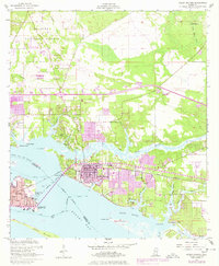
1954 Map of Ocean Springs
USGS Topo · Published 1978About this map
The coastal community of Ocean Springs is captured here during a period of significant post-war expansion along the Mississippi Gulf Coast. The town’s relationship with the water is defined by the Louisville and Nashville railroad and the Memorial Bridge connecting it westward to Biloxi. The map reveals a complex network of coastal waterways including the Old Fort Bayou, Back Bay of Biloxi, and the sheltered waters behind Deer Island. Beyond the established town center, newer developments like Gulf Hills and Halstead emerge, while the northern reaches remain largely under the canopy of the De Soto National Forest. A notable 1970s photorevision layer in purple highlights the rapid growth of residential tracts and trailer parks near the Gulfpark Airport, illustrating the suburbanization that transformed the Jackson County shoreline decades after the initial 1954 survey.
Find a feature on this map
48 named features on this map. Tap any name to fly to it.
Don’t see what you’re looking for? This feature index may not catch every label — zoom into the map to look around manually.
Map Details
Editions of this 1954 Ocean Springs Map
5 editions found
Other maps of this area

1941 · Vancleave
USGS Topo · 1:62,500

1943 · Pascagoula
USGS Topo · 1:62,500

1943 · Vancleave
USGS Topo · 1:62,500

1944 · Vancleave
USGS Topo · 1:62,500

1953 · Mobile
USGS Topo · 1:250,000

1954 · Vestry
USGS Topo · 1:62,500

1954 · Ocean Springs
USGS Topo · 1:24,000

1954 · Biloxi
USGS Topo · 1:24,000

1954 · Deer Island
USGS Topo · 1:24,000

1954 · Biloxi
USGS Topo · 1:62,500
Featured Places
- Biloxi, MS
- Ocean Springs, MS
- Fort Bayou Estates, Ocean Springs
- Gulf Hills, MS
- Martins Pine Hill Estates, MS