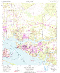
1954 Map of Ocean Springs
USGS Topo · Published 1991About this map
Biloxi and Ocean Springs dominate the shoreline of this coastal survey, where the Back Bay of Biloxi meets Biloxi Bay. The landscape is defined by an intricate network of waterways, including Old Fort Bayou and numerous smaller inlets like St Martin Bayou and Halstead Bayou. The Louisville and Nashville Railroad serves as a primary east-west corridor, crossing the water via the Memorial Bridge and connecting the core developed areas.
Find a feature on this map
49 named features on this map. Tap any name to fly to it.
Don’t see what you’re looking for? This feature index may not catch every label — zoom into the map to look around manually.
Map Details
Editions of this 1954 Ocean Springs Map
5 editions found
Other maps of this area

1941 · Vancleave
USGS Topo · 1:62,500

1943 · Pascagoula
USGS Topo · 1:62,500

1943 · Vancleave
USGS Topo · 1:62,500

1944 · Vancleave
USGS Topo · 1:62,500

1953 · Mobile
USGS Topo · 1:250,000

1954 · Vestry
USGS Topo · 1:62,500

1954 · Ocean Springs
USGS Topo · 1:24,000

1954 · Biloxi
USGS Topo · 1:24,000

1954 · Deer Island
USGS Topo · 1:24,000

1954 · Biloxi
USGS Topo · 1:62,500
Featured Places
- Biloxi, MS
- Ocean Springs, MS
- Fort Bayou Estates, Ocean Springs
- Gulf Hills, MS
- Martins Pine Hill Estates, MS