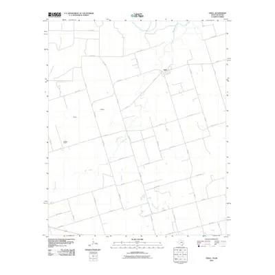
2010 Map of Odell
USGS Topo · Published 2010About this map
The Odell community sits in the northern reaches of Wilbarger County, where the agricultural plains meet the winding course of the Red River. This landscape is defined by the drainage basins of Wanderers Creek and Wildcat Creek, which carve through the flat farm acreage. The settlement pattern here is characterized by a grid of farm-to-market roads and county lines that connect remote homesteads and larger operations such as Moffett Ranch. Significant terrain features like Plum Hollow break the geometric regularity of the surrounding fields. The area's reliance on the local waterway system is evident in the way FM 91 W and FM 924 provide essential links between these disparate rural holdings and the primary crossing points near the river border with Oklahoma.
Find a feature on this map
30 named features on this map. Tap any name to fly to it.
Don’t see what you’re looking for? This feature index may not catch every label — zoom into the map to look around manually.
Map Details
Editions of this 2010 Odell Map
This is the sole edition of this map. No revisions or reprints were ever made.
Other maps of this area

1955 · Lawton
USGS Topo · 1:250,000

1958 · Vernon
USGS Topo · 1:62,500

1958 · Medicine Mound
USGS Topo · 1:62,500

1958 · Elmer
USGS Topo · 1:62,500

1960 · Quanah
USGS Topo · 1:62,500

1975 · Elmore City NE
USGS Topo · 1:24,000

1975 · Quanah NE
USGS Topo · 1:24,000

1983 · Tolbert
USGS Topo · 1:24,000
1983 · Vernon
USGS Topo · 1:24,000
1983 · Medicine Mound
USGS Topo · 1:24,000