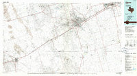
1986 Map of Odessa
USGS Topo · Published 1994About this map
The Permian Basin industrial landscape is defined here by a dense grid of production, where the Goldsmith Oil Field and North Cowden Oil Field dominate the terrain between the growing urban centers of Odessa and Midland. This 1:100,000-scale planimetric survey captures the region as it matured in the mid-1980s, illustrating how the petroleum industry shaped settlement patterns in West Texas. Beyond the city limits, smaller outposts like Goldsmith and Notrees serve as hubs for the surrounding fields, while the Texas and Pacific RR remains a primary transit corridor connecting Monahans to the larger metro areas.
Find a feature on this map
48 named features on this map. Tap any name to fly to it.
Don’t see what you’re looking for? This feature index may not catch every label — zoom into the map to look around manually.
Map Details
Editions of this 1986 Odessa Map
2 editions found
Other maps of this area

1928 · Crane
USGS Topo · 1:125,000

1928 · Rankin
USGS Topo · 1:125,000

1931 · Barstow
USGS Topo · 1:125,000

1954 · Hobbs
USGS Topo · 1:250,000

1954 · Pecos
USGS Topo · 1:250,000

1954 · Big Spring
USGS Topo · 1:250,000

1954 · San Angelo
USGS Topo · 1:250,000

1957 · Pecos
USGS Topo · 1:250,000

1958 · San Angelo
USGS Topo · 1:250,000

1958 · Big Spring
USGS Topo · 1:250,000