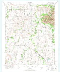
1956 Map of Odetta
USGS Topo · Published 1974About this map
Wichita Mountains terrain dominates the northeastern portion of this mid-century survey, where the rugged peaks of Sunset Peak and Charons Garden Mountain overlook the Wichita Mountains Wildlife Refuge. The landscape transitions from the jagged granite outcrops and Bad Lands of the wildlife area to the lower plains of the Fort Sill Military Reservation in the southeast. Transportation through this frontier-like environment is defined by the St Louis San Francisco railroad line, which provides a transit link for the small settlements of Odetta and Homa. Multiple drainage systems including Sandy Creek, Otter Creek, and Post Oak Creek carve through the divide between Kiowa and Comanche counties, illustrating the complex hydrology of the region before significant modern development altered the local water table.
Find a feature on this map
18 named features on this map. Tap any name to fly to it.
Don’t see what you’re looking for? This feature index may not catch every label — zoom into the map to look around manually.
Map Details
Editions of this 1956 Odetta Map
3 editions found

Other maps of this area

1937 · Cache
USGS Topo · 1:48,000

1937 · Quanah Mountain
USGS Topo · 1:24,000

1942 · Cache
USGS Topo · 1:62,500

1949 · Cooperton
USGS Topo · 1:62,500

1949 · Quanah Mountain
USGS Topo · 1:24,000

1950 · Snyder
USGS Topo · 1:62,500

1950 · Saddle Mountain
USGS Topo · 1:62,500

1955 · Lawton
USGS Topo · 1:250,000

1956 · Post Oak Creek
USGS Topo · 1:24,000

1956 · Glen Mountains
USGS Topo · 1:24,000