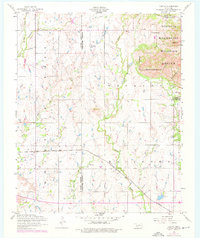
1956 Map of Odetta
USGS Topo · Published 1976About this map
The St Louis San Francisco railroad cuts a straight path through the southwestern Oklahoma plains, serving the small settlement of Odetta as it travels toward the Kiowa County and Comanche County line. The landscape transitions sharply in the northeast, where the granite rises of the Wichita Mountains emerge. Significant landmarks include Charons Garden Mountain and Sunset Peak, situated within the protected bounds of the Wichita Mountains Wildlife Refuge. This survey captures the region during a period of administrative stability, showing the eastern edge of the quadrangle dominated by the Fort Sill Military Reservation. Water sources such as Cottonwood Spring and Sandy Creek provide vital drainage for the rugged Bad Lands and Broken Hills terrain that defines the high ground north of the rail line.
Find a feature on this map
22 named features on this map. Tap any name to fly to it.
Don’t see what you’re looking for? This feature index may not catch every label — zoom into the map to look around manually.
Map Details
Editions of this 1956 Odetta Map
3 editions found

Other maps of this area

1937 · Cache
USGS Topo · 1:48,000

1937 · Quanah Mountain
USGS Topo · 1:24,000

1942 · Cache
USGS Topo · 1:62,500

1949 · Cooperton
USGS Topo · 1:62,500

1949 · Quanah Mountain
USGS Topo · 1:24,000

1950 · Snyder
USGS Topo · 1:62,500

1950 · Saddle Mountain
USGS Topo · 1:62,500

1955 · Lawton
USGS Topo · 1:250,000

1956 · Post Oak Creek
USGS Topo · 1:24,000

1956 · Glen Mountains
USGS Topo · 1:24,000