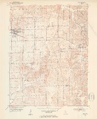
1950 Map of Odon
USGS Topo · Published 1953About this map
The town of Odon serves as the primary hub in this mid-century survey of northeastern Daviess County. The landscape is defined by the heavy infrastructure of the Chicago Milwaukee ST Paul And Pacific railroad, which cuts east-west through the terrain, connecting the larger settlement of Odon with the eastern community of Burns City. To the east, the boundary of the Crane Naval Ammunition Depot marks a significant shift in land use, where rugged ridges like Pigeon Ridge contrast with the agricultural lowlands of the Madison and Van Buren townships.
Find a feature on this map
26 named features on this map. Tap any name to fly to it.
Don’t see what you’re looking for? This feature index may not catch every label — zoom into the map to look around manually.
Map Details
Editions of this 1950 Odon Map
2 editions found
Other maps of this area

1943 · Lyons
USGS Topo · 1:24,000

1943 · Epsom
USGS Topo · 1:24,000

1944 · Montgomery
USGS Topo · 1:24,000

1950 · Shoals
USGS Topo · 1:24,000

1950 · Odon
USGS Topo · 1:24,000

1956 · Loogootee
USGS Topo · 1:24,000

1956 · Koleen
USGS Topo · 1:24,000

1956 · Indian Springs
USGS Topo · 1:24,000

1956 · Vincennes
USGS Topo · 1:250,000

1957 · Vincennes
USGS Topo · 1:250,000