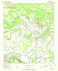
1950 Map of Ogden
USGS Topo · Published 1971About this map
The Red River meanders across the border of Arkansas and Texas, defining a landscape of oxbow lakes and bottomlands at the mid-century. The settlement of Ogden serves as a central hub, situated along the Kansas City Southern railroad line. This period of the 1950s shows a significant concentration of local educational landmarks, including the Washington Sch and Rosenwald Sch in the north, and Clear Lake Sch further west. These schools, alongside St Johns Ch and New Zion Ch, reflect a distributed rural community structure typical of the era. The hydrology of the area is particularly complex, characterized by numerous water bodies like Mill Lake, First Lake, and Brushy Lake, which were carved out by the shifting path of the river. To the south, the Texarkana Radio Range Station and the settlement of Wamba indicate the growing infrastructure near the state line.
Find a feature on this map
36 named features on this map. Tap any name to fly to it.
Don’t see what you’re looking for? This feature index may not catch every label — zoom into the map to look around manually.
Map Details
Editions of this 1950 Ogden Map
4 editions found
Other maps of this area

1909 · Texarkana
USGS Topo · 1:62,500

1950 · Ashdown East
USGS Topo · 1:24,000

1950 · Ashdown West
USGS Topo · 1:24,000

1950 · Ogden
USGS Topo · 1:24,000

1950 · Red Bluff
USGS Topo · 1:24,000

1950 · Barkman
USGS Topo · 1:24,000

1951 · Ashdown West
USGS Topo · 1:24,000

1951 · Ogden
USGS Topo · 1:24,000

1951 · Red Bluff
USGS Topo · 1:24,000

1951 · Ashdown East
USGS Topo · 1:24,000