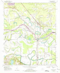
1950 Map of Ogden
USGS Topo · Published 1975About this map
The Red River dominates this landscape along the border of Arkansas and Texas, its winding course defining the boundaries between Little River, Miller, and Bowie counties. The town of Ogden serves as a central hub along the Kansas City Southern railroad line, surrounded by a complex network of oxbow lakes including First Lake, Pleasant Lake, and Winham Lake. These water bodies and the accompanying levee systems illustrate the persistent efforts to manage the river's flood-prone bottomlands for agriculture and settlement.
Find a feature on this map
39 named features on this map. Tap any name to fly to it.
Don’t see what you’re looking for? This feature index may not catch every label — zoom into the map to look around manually.
Map Details
Editions of this 1950 Ogden Map
4 editions found
Other maps of this area

1909 · Texarkana
USGS Topo · 1:62,500

1950 · Ashdown East
USGS Topo · 1:24,000

1950 · Ashdown West
USGS Topo · 1:24,000

1950 · Ogden
USGS Topo · 1:24,000

1950 · Red Bluff
USGS Topo · 1:24,000

1950 · Barkman
USGS Topo · 1:24,000

1951 · Ashdown West
USGS Topo · 1:24,000

1951 · Ogden
USGS Topo · 1:24,000

1951 · Red Bluff
USGS Topo · 1:24,000

1951 · Ashdown East
USGS Topo · 1:24,000