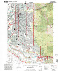
1998 Map of Ogden
USGS Topo · Published 2001About this map
Ogden and its surrounding communities are captured here as the city meets the base of the Wasatch Range. The urban grid is dense with civic and religious institutions, from Ogden High Sch to St Paul Lutheran Sch, while the City Cemetery and Memorial Gardens of the Wasatch provide significant landmarks for genealogical research. The landscape is defined by the confluence of the Ogden River and Weber River, which carved the valleys that now host the Union Pacific Railroad and Southern Pacific Railroad corridors.
Find a feature on this map
72 named features on this map. Tap any name to fly to it.
Don’t see what you’re looking for? This feature index may not catch every label — zoom into the map to look around manually.
Map Details
Editions of this 1998 Ogden Map
This is the sole edition of this map. No revisions or reprints were ever made.
Other maps of this area

1954 · Ogden
USGS Topo · 1:250,000

1954 · Brigham City
USGS Topo · 1:250,000

1955 · Ogden
USGS Topo · 1:24,000

1955 · Plain City
USGS Topo · 1:24,000

1955 · Clearfield
USGS Topo · 1:24,000

1955 · Roy
USGS Topo · 1:24,000

1955 · Peterson
USGS Topo · 1:24,000

1955 · Huntsville
USGS Topo · 1:24,000

1955 · North Ogden
USGS Topo · 1:24,000

1955 · Kaysville
USGS Topo · 1:24,000