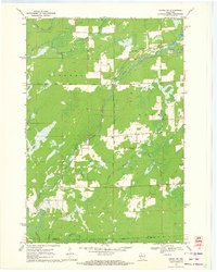
1970 Map of Ogema NW
USGS Topo · Published 1972About this map
The Fourth Principal Meridian serves as a central north-south axis through this northern Wisconsin landscape, where the town of Ogema meets Catawba. The terrain is defined by the winding waters of the North Fork Jump River and the South Fork Jump River, creating a complex network of wetlands and drainage basins. Local elevations are marked by landmarks like Hallberg Hill, while the southern reaches of the map intersect with the Chequamegon National Forest Boundary.
Find a feature on this map
16 named features on this map. Tap any name to fly to it.
Don’t see what you’re looking for? This feature index may not catch every label — zoom into the map to look around manually.
Map Details
Editions of this 1970 Ogema NW Map
2 editions found
Other maps of this area

1941 · Kennan
USGS Topo · 1:48,000

1941 · Phillips
USGS Topo · 1:48,000

1943 · Philliips
USGS Topo · 1:48,000

1944 · Ogema
USGS Topo · 1:48,000

1945 · Kennan
USGS Topo · 1:48,000

1945 · Black River
USGS Topo · 1:48,000

1947 · Ogema
USGS Topo · 1:48,000

1949 · Ogema
USGS Topo · 1:48,000

1949 · Jump River Fire Tower
USGS Topo · 1:48,000

1953 · Rice Lake
USGS Topo · 1:250,000