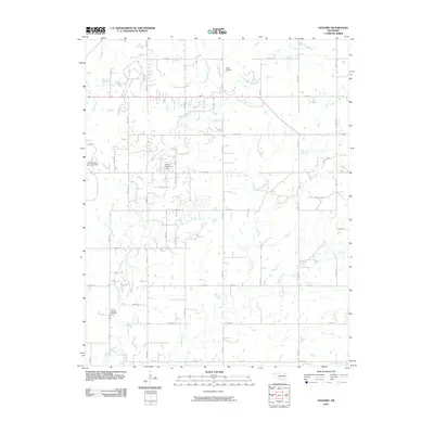
2010 Map of Oglesby
USGS Topo · Published 2010About this map
Hogshooter Creek and Curl Creek dominate the landscape of Washington County in this early 21st-century survey. The rural character of the area is defined by a dense grid of township and range roads, providing access to remote properties and agricultural land. Significant for local historians and genealogists, the map identifies the locations of Oglesby Cemetery in the southwest and Willey Cemetery to the north, preserving these burial sites within the modern road network. The persistent influence of the petroleum industry is evident in the northeast, where specialized Oilwell Roads branch off the primary thoroughfares like W 2200 Rd. Minor waterways, including Fish Creek and Fourmile Creek, lace through the sections, illustrating the drainage patterns that have shaped the development of these Oklahoma prairies.
Find a feature on this map
38 named features on this map. Tap any name to fly to it.
Don’t see what you’re looking for? This feature index may not catch every label — zoom into the map to look around manually.
Map Details
Editions of this 2010 Oglesby Map
This is the sole edition of this map. No revisions or reprints were ever made.
Other maps of this area

1901 · Nowata
USGS Topo · 1:125,000

1914 · Nowata
USGS Topo · 1:125,000

1954 · Tulsa
USGS Topo · 1:250,000

1958 · Tulsa
USGS Topo · 1:250,000

1963 · Tulsa
USGS Topo · 1:250,000

1970 · Bartlesville SE
USGS Topo · 1:24,000
1970 · Talala
USGS Topo · 1:24,000
1971 · Bartlesville South
USGS Topo · 1:24,000
1971 · Bartlesville North
USGS Topo · 1:24,000

1972 · Blue Mound
USGS Topo · 1:24,000