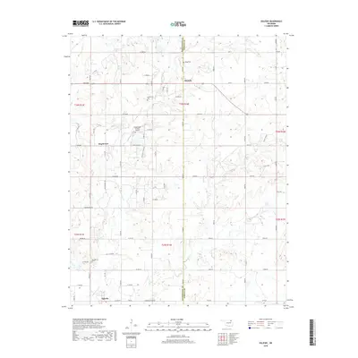
2018 Map of Oglesby
USGS Topo · Published 2018About this map
Hogshooter Cr and its various tributaries define the landscape of this region along the border of Washington and Nowata counties. The settlement of Oglesby serves as a southern anchor for the area, while Glenoak is situated further north along the county line. The rural character of the territory is evidenced by a network of sectional roads such as Rice Creek Rd and Smokerise Ranch Rd, which connect scattered homesteads and ranches.
Find a feature on this map
41 named features on this map. Tap any name to fly to it.
Don’t see what you’re looking for? This feature index may not catch every label — zoom into the map to look around manually.
Map Details
Editions of this 2018 Oglesby Map
This is the sole edition of this map. No revisions or reprints were ever made.
Other maps of this area

1901 · Nowata
USGS Topo · 1:125,000

1914 · Nowata
USGS Topo · 1:125,000

1954 · Tulsa
USGS Topo · 1:250,000

1958 · Tulsa
USGS Topo · 1:250,000

1963 · Tulsa
USGS Topo · 1:250,000

1970 · Bartlesville SE
USGS Topo · 1:24,000
1970 · Talala
USGS Topo · 1:24,000
1971 · Bartlesville South
USGS Topo · 1:24,000
1971 · Bartlesville North
USGS Topo · 1:24,000

1972 · Blue Mound
USGS Topo · 1:24,000