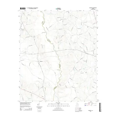
2014 Map of Ohoopee
USGS Topo · Published 2014About this map
The Ohoopee River winds south through the heart of this rural landscape, forming the natural boundary between Toombs and Tattnall Counties. In this stretch of the Georgia coastal plain, the settlement of Ohoopee serves as a central hub, connected by roads such as Ga-86 and Ga-292. The map reveals a land defined by its creek systems, including Pendleton Cr and Brazells Cr, alongside industrial water features like Weyherhauser Lake. Numerous family-named burial grounds are scattered across the quadrangle, including Findley Cem, Mt Zion Cem, and Saturday Cem, providing vital waypoints for those researching local family lineages and early church locations in this predominantly agricultural region.
Find a feature on this map
93 named features on this map. Tap any name to fly to it.
Don’t see what you’re looking for? This feature index may not catch every label — zoom into the map to look around manually.
Map Details
Editions of this 2014 Ohoopee Map
This is the sole edition of this map. No revisions or reprints were ever made.
Other maps of this area

1957 · Macon
USGS Topo · 1:250,000

1958 · Macon
USGS Topo · 1:250,000

1964 · Macon
USGS Topo · 1:250,000

1970 · Cobbtown
USGS Topo · 1:24,000
1970 · Collins
USGS Topo · 1:24,000

1970 · Johnson Corner
USGS Topo · 1:24,000
1970 · Metter SE
USGS Topo · 1:24,000

1970 · Ohoopee
USGS Topo · 1:24,000

1970 · Reidsville West
USGS Topo · 1:24,000

1970 · Lyons
USGS Topo · 1:24,000