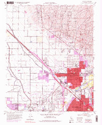
1954 Map of Oildale
USGS Topo · Published 1979About this map
Kern Front Oil Field and the Kern River Oil Field dominate the landscape north of the Kern River, illustrating the mid-century petroleum industry that fueled the region's growth. The expansion of Oildale is evident, showing residential growth pressing against industrial zones and the County Airport. The map documents a complex irrigation network, with the Lerdo Canal, Beardsley Canal, and Calloway Canal channeling water through the valley to support local agriculture alongside heavy industry.
Find a feature on this map
53 named features on this map. Tap any name to fly to it.
Don’t see what you’re looking for? This feature index may not catch every label — zoom into the map to look around manually.
Map Details
Editions of this 1954 Oildale Map
4 editions found
Other maps of this area

1906 · Bakersfield
USGS Topo · 1:62,500

1910 · Buena Vista Lake
USGS Topo · 1:125,000

1912 · Buena Vista Lake
USGS Topo · 1:125,000

1914 · Caliente
USGS Topo · 1:125,000

1929 · Stevens
USGS Topo · 1:31,680

1929 · Fairfax School
USGS Topo · 1:31,680

1930 · Famoso
USGS Topo · 1:31,680

1930 · Rosedale
USGS Topo · 1:31,680

1930 · Oildale
USGS Topo · 1:31,680

1932 · North of Oildale
USGS Topo · 1:31,680